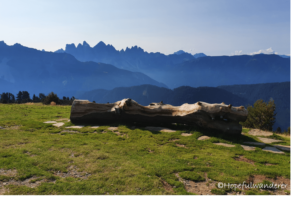
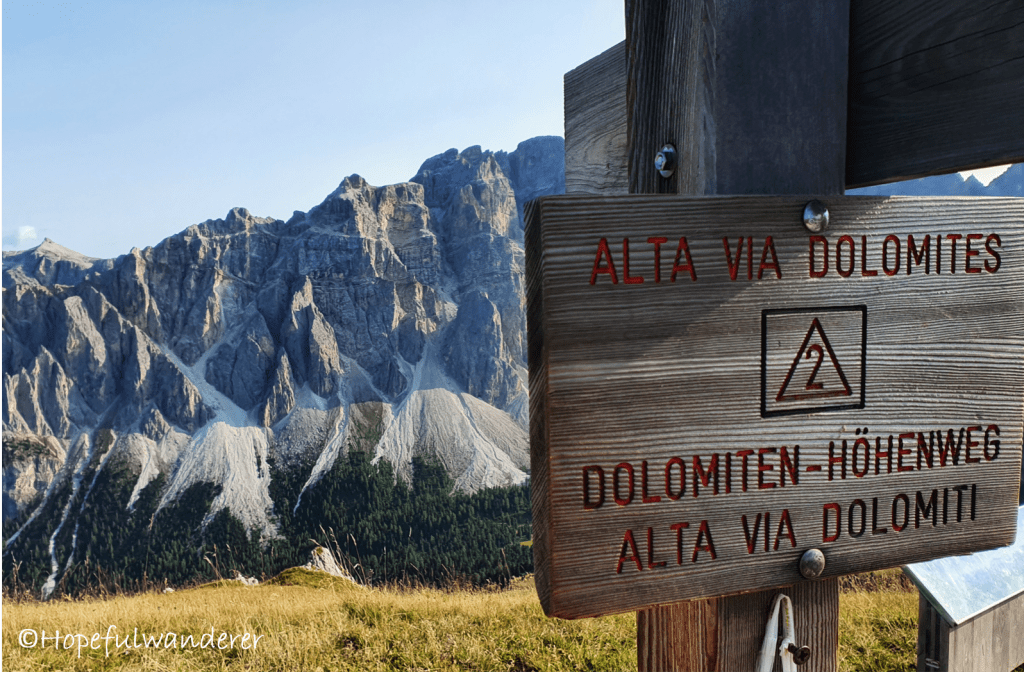
Alta Via 2 (High route 2) is around 150 – 160 km long trail in the Dolomites (northern Italy/South Tyrol). The total cumulative ascent is around 10 km (note: the altitude gain is the same as on the GR 240 – Sulayr trail, except Sulayr is twice as long, so be prepared for some serious climbing). The highest point is around 2,960 meters above sea level.
STRUCTURE and TRANSPORT
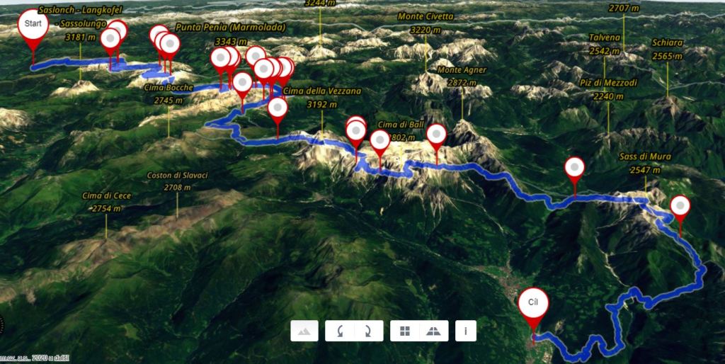
The trail officially starts in Bressanonne/Brixen – a cozy town situated just 50 km from the Austrian border and stretches southbound all the way to Croce d’Aune – village in Belluno province. From Croce d’Aune one can take a bus to Feltre (or alternatively walk all the way there instead of finishing in Croce d’Aune). Feltre is definitely worth a visit. There are buses from Feltre to Trento and from there direct trains all the way back to Brixen.
The trail is oficially divided into 12-13 stages. Total distance is around 160 km, time needed to complete the hike varies between 10 to 14 days. We finished our journey after 10 days but we skipped the first stage (Bressanone/Brixen – Plose) and took cable car instead because we wanted to save time and energy as well as the last stage (Rifugio Boz – Croce d’Aune) because we were stressed and exhausted after having survived the scariest night of our lives. In addition, the weather got really bad and it started to be a bit slippery and dangerous.
SOUTHBOUND
This is a bit peculiar from my viewpoint, since most trails typically lead from the south to the north. Which by the way has it’s logic behind – if nothing else, you don’t have the sun shinning in your face all day long. So when hiking Alta Via 2, we were thinking “why the hell does the official version go southbound? Maybe next time, should we hike it again, we would go northbound.“ But looking back, I would not recommend this! There were a few moments, few difficult passes and via ferratas when we were really happy that we were NOT hiking in the opposite direction.
Speaking of ferratas….
DIFFICULTY
I am by no means any sort of a hiking expert and this is only my personal opinion based on my experience and current level but I found this trek really damn difficult and challenging (both physically and sometimes even technically) and I would recommend it to experienced hikers only. The average daily ascent and descent were around 868 m and 977 m respectively on an average daily distance of 14,35 km. Combined with a difficult terrain, occassional ferratas and the load we carried, it was a killer.
GEAR
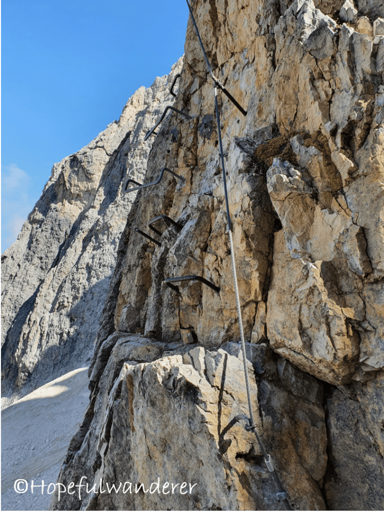
As mentioned, there are some via ferratas on the trail, I would say they are doable without FERRATA GEAR (unless you are afraid of heights) but I would generally recommend taking the gear. At the same time, TREKKING POLES are essential. Take them! Even if you are not used to hiking with poles, even if you are trekking poles hater, take them!! (and thank me later). They will come in very useful and will be a great help to you. I was also hesitant about which shoes to hike in. Finally I opted for my hiking BOOTS rather than for my light trekking sneakers and I was immensely grateful for this choise. The terrain on Alta Via 2 is rough – slippery rubble, sharp spiky rocks, greasy clay…. Honestly I can’t imagine hiking on it without those firm ankle-high boots with solid sole. But this is again rather my personal preference driven by the fact that a) I am not an ultra-light hiker, hence I carry heavier backpack (17-18 kg full load) and b) I have problems with sprained ankles, so I need the additional support and fixation provided by high boots.
What you may also need to know:
- On Day 5 (from Lago di Fedaia onwards), there are two options how to continue the Alta Via 2. One of them involves crossing an ice-field. For this you will need CRAMPONS (or at least MICROSPIKES) and an ICE-AXE. Without it, it’s impossible to cross the field! (trust me, we’ve tried :-D…and nearly died)…otherwise you will be forced to take a detour through Malga Ciapella village.
- There ARE (brown) BEARS in the Dolomites! We have been stalked by 2 during our last night on trail and I can tell you it was the most horrifying experience of our lives. Seriously, BEAR this in mind and minimize your chance to encounter a BEAR :). Follow the basic rules of hiking in the bear country because this absolutely is one!
NAVIGATION and ORIENTATION
The trail is (sort of) marked but not that well in my view. I would definitely recommend taking a paper map or downloading GPS coordinates. We relied on our favourite offline maps downloaded from mapy.cz but those were not 100% reliable either when it came to Alta Via 2. And so there were moments of hesitation whether we are on a good path or where we should go next. Nevertheless, we soon discovered one simple rule – just take the most difficult, uninviting and shitty path at choice…the path that you would never pick…Because THAT is usually Alta Via 2.
HUT-TO-HUT vs. WILD CAMPING
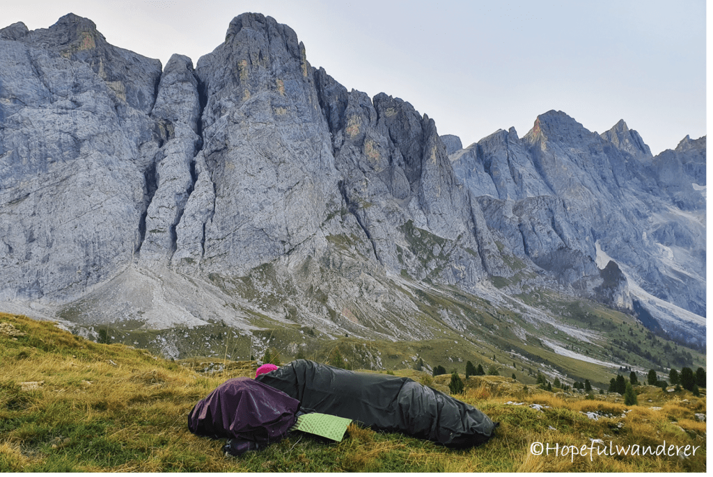
We did not go hut-to-hut (which is let’s say the “official way” of how to hike this trail) mostly because we like the freedom of sleeping under the stars and the freedom to chose our daily mileage. We were either bivouacking (this was before we found out that there are bears on Alta Via 2) or sleeping in a tent always trying to follow the LNT (“Leave No Trace“ principles) the best we could.
Seems that the camping rules/legislation in the Dolomites are not 100% clear. In short, what I understood is that:
- “Camping” defined as spending 48 hours or more in one place in a tent is strictly prohibited. However, this is most likely not something we are up to here
- “Overnight bivouacking” meaning cowboy camping (without a tent) from evening to morning seems to be permitted.
- “Overnight camping in a tent“, i.e. setting up a tent for one night should be done only in case of emergency. Aparently you could be confronted by a forest guard (but I would bet the same goes for bivouacking). Furthermore, how exactly is “case of emergency” defined?
Taking all of this into account, I was a bit nervous almost every night that someone might come to check on us and that we might have to explain…but it never happened. Paradoxically, it did not happen during the last night either despite the facts that a) we were just few hundreds of meters far from a hut and b) we were making so much noise that the half of Italy must have known about us. And I was actually desperatelly wishing for someone to come…”Why?” are you wondering? Well, it had something to do with the bear…but more about this later.
All in all I would say that overnight stays are fine. At least we never had a problem (with people). If you are going to cowboy camp, please note that chances are you will be fighting with condensation and wet bivouc sack/sleeping bag in the morning as the climate in the Dolomites seems to be very humid.
FREE SHELTERS ON TRAIL (BIVACCOS)
There are also some free “bivaccos”, i.e. “emergency shelters” on the trail, where one can spend the night. Some of them are located directly next to the huts (“rifugios”) and can be used only outside of the season (past mid-September) when the hut itself is closed. Furthermore, we have seen some signs saying that these bivaccos are closed in 2020 due to COVID-19 but they were not locked and we even met people who used them.
- Bivacco Brunner (stage 8)
- Bivacco Carlo Minazio (stage 9)
- Bivacco Feltre-Bodo (stage 11)
- Bivacco Rif Bruno Boz (stage 12)
WATER ON THE TRAIL
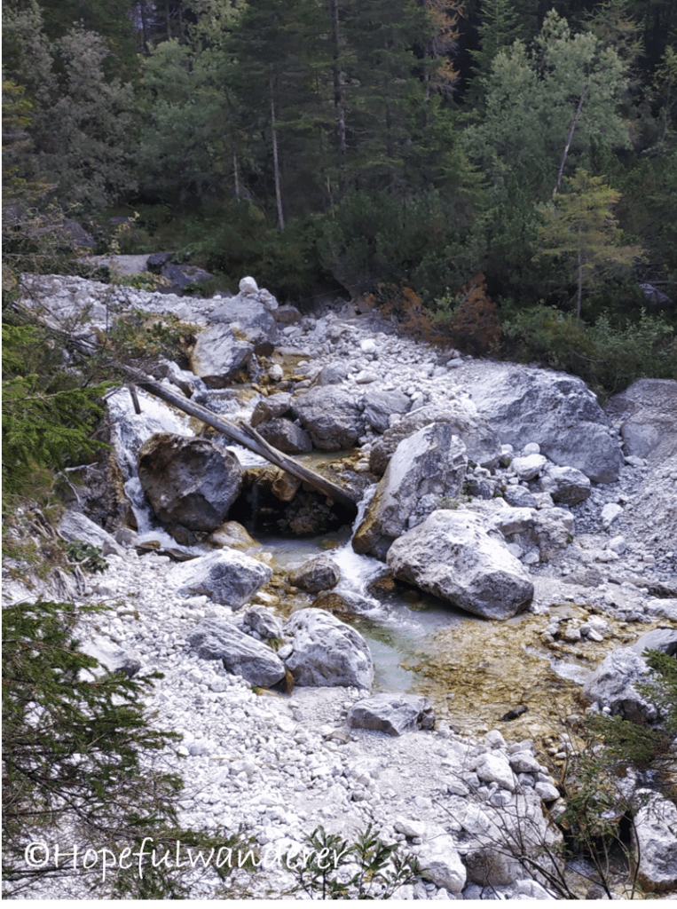
The water is definitely not ubiquitous on the trail. Especially in the upper rocky areas, it is rather scarce. Plan ahead and always be aware of where your next water source is (especially if you are using water also for cooking)
As always, I would recommend packing a water filter (I’m using Sawyer squeeze but there are many other tools for water purification out there on the market)
Otherwise it is also possible to buy a bottled water on the huts. You should also try local speciality – “limón-soda” – lemonade sold on the huts. It’s very sweet but refreshing.
WHEN TO HIKE:
- August – September
The general advice is to hike Alta Via till mid-September which is when the season ends, most of the huts close and cable cars stop operating. We started our hike on September 13th. Given that we were more or less self-sufficient, our initial thought was that we might have started even later (end of September/beginning of October) in order to avoid crowds. Nevertheless, it turned out that our timing was on the edge and that we might have wanted to start even slightly earlier. Why?
- We wanted to re-supply in Malga Ciapella village but when we arrived on September 17th, everything was closed already…
- We were lucky that we caught a cable-car on its last day of operation which took us to other re-supply point – San Martino di Castrozza . This was on September 20th.
- Coming closer to the end of September, the weather got bad and kept worsening each day (it was rainy, foggy and humid all the time). The weather sitution may of course differ each year but I would say if you want to minimize your chances of bad weather, August/first half of September might be a safer bet. Unless you want to risk being faced with poor weather conditions and potentially even snow, I wouldn’t consider October whatsover.